This article is a practical guide to leveraging common seismic attributes for enhanced geological interpretation, more specifically, how to make the best out of paraphase and phase rotation. It is shared by our Senior Geophysicist, Per Schrüfer.
Seismic interpreters routinely utilise various attributes within interpretation software to enhance their understanding of subsurface geology. Whilst this technical note uses examples from S&P Kingdom software, these attributes are standard features available in most seismic interpretation packages. Here, we focus on two particularly useful attributes – paraphase analysis and phase rotation – and demonstrate how they can be effectively applied in daily interpretation workflows.
Paraphase: A tool for enhanced feature recognition
Paraphase attribute transforms conventional seismic amplitude data by removing predictable phase trends. This transformation offers practical advantages in routine interpretation tasks. When comparing conventional amplitude displays with paraphase displays, wide amplitude troughs are concentrated into distinct, narrow peaks, whilst amplitude peaks become more diffuse.
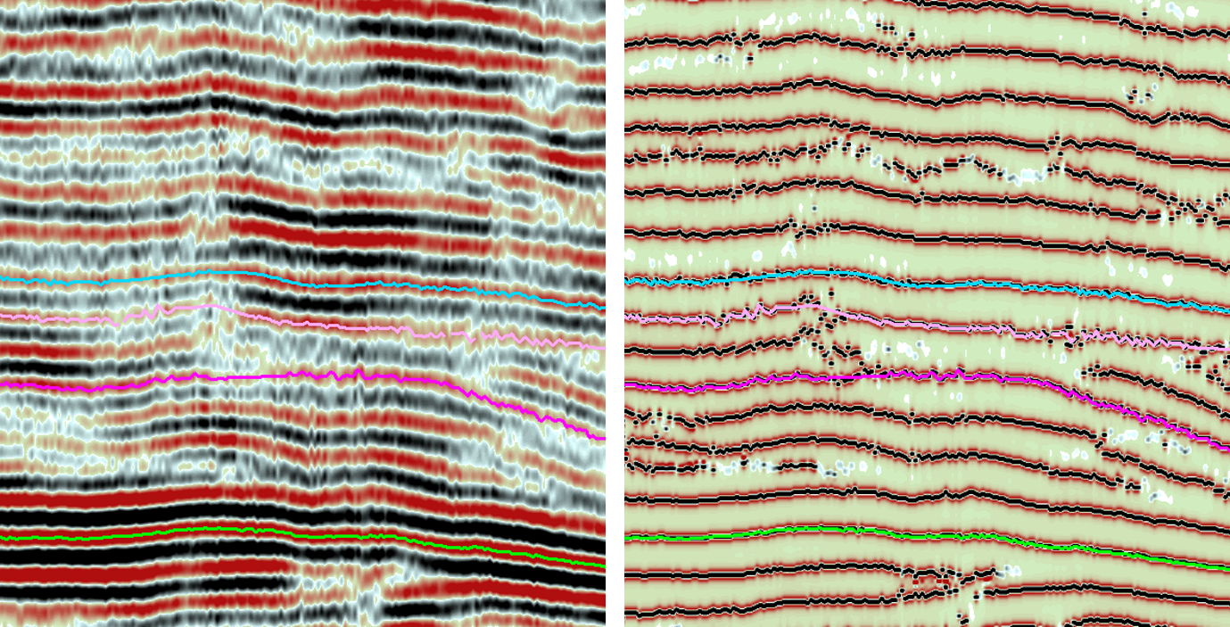
Fig. a) The panel above shows a conventional amplitude display to the left and a paraphase display to the right.
Why use paraphase in daily interpretation?
- Internal reservoir geometries become more visible than in conventional amplitude displays
- Fault interpretation benefits from sharper imaging
- Detailed structural mapping is facilitated by enhanced feature definition
Interpreters should note that whilst horizon picks on paraphase displays may appear slightly rougher than conventional amplitude picks, these variations are minimal. Switching between paraphase and amplitude picking (alternating between peak and trough) produces consistent horizons with only minor roughness effects.
Phase Rotation: A tool requiring geological justification
Phase rotation can potentially address well-tie challenges, but its application must be carefully justified by geological evidence. Before applying any phase rotation, interpreters should:
- Establish a clear geological reasoning for the misalignment between seismic and well data
- Verify that the misalignment is consistent across multiple wells in the same stratigraphic interval
- Consider other potential causes for the misalignment, such as processing artefacts or velocity model issues
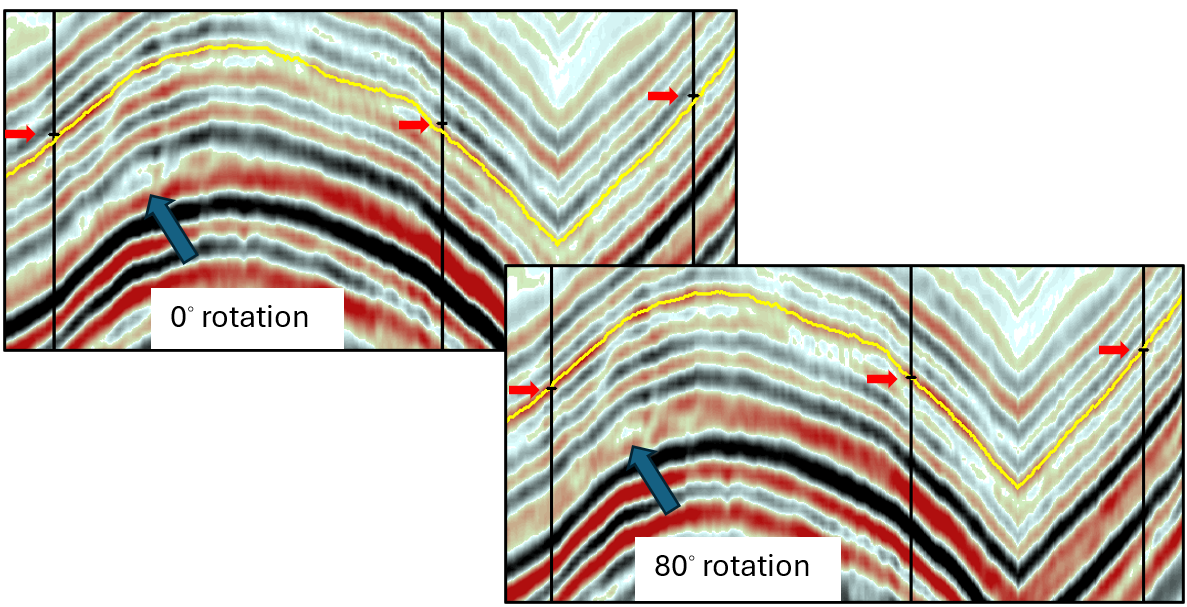
Fig. b) Section through three wells without phase rotation on the left and with 80-degrees rotation on the right. The yellow horizon is picked on the respective trough in each section.
The example showing three wells where an 80-degree rotation reduced residuals represents just one case study. Such significant phase adjustments should not be applied without thorough investigation and documentation of the geological context. The technique remains highly empirical and should be used cautiously, as it can introduce artefacts or mask real geological features.
Why use phase rotation?
- Document the geological justification for applying phase rotation
- Maintain consistent rotation values throughout interpretation to avoid horizon discontinuities
- Validate results against all available well control, not just the wells showing improvement
- Consider the impact on other stratigraphic intervals affected by the rotation
These attributes represent established tools within seismic interpretation software that, when properly applied, can enhance interpretation efficiency and accuracy. Understanding their practical applications, limitations, and the need for geological justification helps interpreters make appropriate use of these capabilities in their daily work.
Sharing best practices
While these techniques are well-established in the geophysical toolbox, their optimal application relies on experience and context. The geophysical community benefits most when interpreters document their workflows using these attributes, particularly noting the geological context that led to successful applications. Sharing examples where these techniques proved particularly valuable helps colleagues avoid potential pitfalls and may encourage others to challenge their current interpretation workflow, potentially revealing features previously overlooked.
The effectiveness of these techniques has been demonstrated across various geological settings and data qualities. Their true value emerges when interpreters share their experiences and best practices within their organisations and the broader geophysical community. Please don’t hesitate to contact the author if you would like to learn more about other interpretation techniques, such as frequency decomposition, automated fault extraction, or advanced attribute combinations for specific geological settings. Your feedback and requests will help shape future technical notes addressing the community’s needs.


